GIS Urban Analysis of Coimbra, Portugal
Role: Group project with Buhari Nasir Ahmad | Duration: Spring 2026 | Focus: Geographic Information Systems, Spatial Analysis, Cartographic Design, Multi-Criteria Decision Analysis
This project applied a full semester of GIS coursework to a single real municipality: Coimbra, Portugal. Built entirely in QGIS using the ETRS89 / Portugal TM06 coordinate system, the project layered vector analysis, raster and terrain modeling, cartography, spatial statistics, routing, and formal decision analysis onto one continuous study area, moving from basic boundary extraction to genuinely independent research questions by the end.
The foundation was vector work: loading Portugal's district, municipality, and parish boundaries, then using the Clip and Dissolve tools to isolate and construct clean Coimbra Municipality borders, with area and perimeter calculated through the Field Calculator and cross checked against the Measure Area tool. From there, roads and highways were digitized by hand using line features, buildings and rivers were clipped to the municipal boundary, and river buffer zones were built for proximity analysis. The QuickOSM plugin pulled in schools, hospitals, and parks directly from OpenStreetMap, giving the project a live service infrastructure layer to work with rather than static reference data.
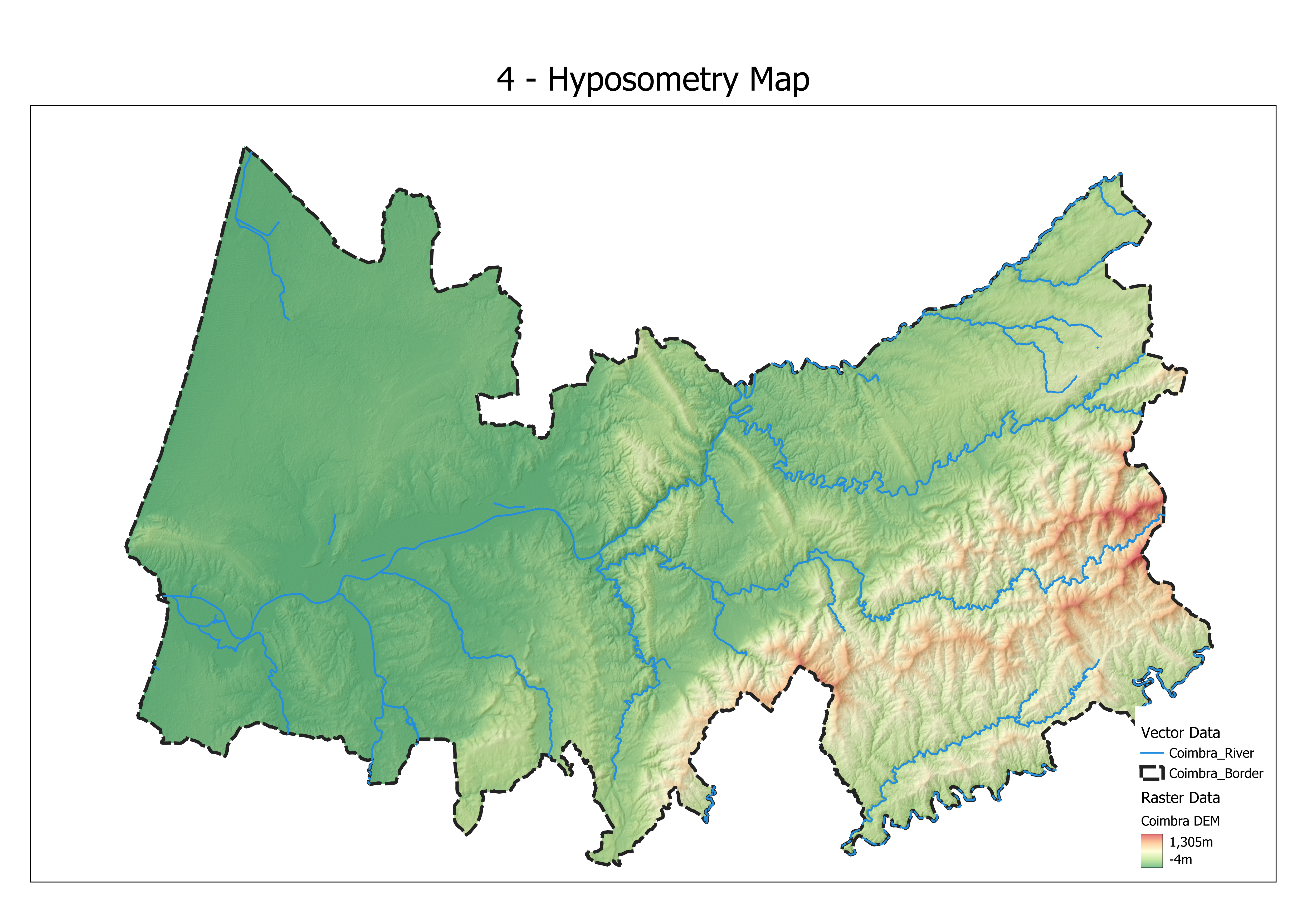
The raster and terrain side of the project centered on a Digital Elevation Model clipped to Coimbra. From that DEM, we generated slope maps, aspect maps showing terrain orientation across all eight compass directions, and hillshade layers for shaded relief visualization. These were combined into an interactive 3D terrain model using the Qgis2threejs plugin, layering in rivers, highways, and both OSM and Google Satellite imagery for a full 3D analytical environment. Contour lines extracted from the DEM were used two ways: to build elevation zone polygons for hypsometric mapping, and to design a pedestrian path layer that follows a constant elevation across the municipality.
Land cover analysis used Portugal's official COS 2023 dataset, filtered down to specific categories like eucalyptus, maritime pine, and stone pine forest. The two pine categories were merged into a single forest layer, and attribute statistics were used to isolate and visualize the single largest maritime pine polygon in the municipality. Demographic analysis drew on INE (Portugal's National Statistics Institute) datasets covering population, households, and buildings at the locality level, mapped with graduated symbology to show population density patterns across Coimbra.
Geoprocessing tools were used extensively to model real spatial relationships rather than just display data: Intersection to isolate parishes and to find overlap between forest and golf course zones, Union to combine land ownership polygons, Difference to measure the impact of roads cutting into forest areas, Buffer paired with Difference for that same road impact analysis, and Voronoi polygons to model service coverage areas around schools, both with and without buffer zones. Routing analysis added a transport layer to the project: the Routing with OSRM plugin calculated shortest paths between locations, and Travelling Salesman Problem tools optimized multi-stop routes between healthcare facilities and pharmacies, exporting distance and time matrices for further analysis.
The most substantial analytical piece was a Multi-Criteria Decision Analysis to identify suitable construction areas in the municipality, run two different ways for comparison. The first used Weighted Linear Combination with manually assigned weights across four reclassified criteria (slope at 0.4, elevation at 0.3, aspect at 0.2, hillshade at 0.1), producing a suitability layer classified from very suitable down to unsuitable. The second used the Analytic Hierarchy Process, generating criteria weights through pairwise comparison via Saaty's Matrix and checking the result against an AHP consistency ratio, then reclassifying and symbolizing it identically to the manual WLC map so the two methods could be compared directly. The same MCDA logic was extended conceptually to landslide susceptibility, factoring in slope, elevation, land cover, distance to rivers, and rainfall as criteria.
Beyond the tutorial based coursework, we extended the project into four independent research threads specific to Coimbra as a university city: mapping student housing concentration and its accessibility to universities and services, tracking gentrification patterns and commercial transformation in specific neighborhoods, identifying nightlife hotspots through mapped bars, restaurants, and entertainment venues, and building a noise pollution model that treats major roads and nightlife districts as potential noise sources with heatmap visualization. A flood susceptibility layer was also built by classifying and polygonizing low elevation DEM zones, and simulated fire event data was rendered as both continuous and discrete heatmaps.
The project closed out with a full cartographic production pass: five thematic print layouts (Overview, Land Cover, Slope, Hypsometry, and Services & Green Zones), each with proper legends, scale bars, north arrows, and coordinate grids, exported as finished PDF and image files.
Skills Demonstrated: QGIS (vector and raster analysis, geoprocessing, cartographic design), Digital Elevation Model processing and terrain analysis, Multi-Criteria Decision Analysis (Weighted Linear Combination and Analytic Hierarchy Process), spatial statistics, routing and Travelling Salesman Problem optimization, working with open geospatial data (OpenStreetMap, INE, COS Land Cover), and 3D terrain visualization.
Details of the full project report and maps can be found here: Google Drive
Category: masters portfolio
149 
0


Comments